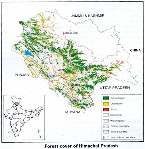
Mani Mahesh Trek
 The spectacular view of the Manimahesh lake and temple in Chamba district of Himachal Pradesh situated 13000 feet above sea-level.—PTI
By Balkrishan Prashar
Manimahesh — the holy Kailash — is located at an altitude of 5656 m. Down the foothills at an altitude of 4170 m nestles the scintillating Manimahesh lake. Mount Kailash, believed to be the abode of Lord Shiva, falls in the Bharmour tribal valley of Chamba district. This pilgrimage centre gains importance on two religious occasions, one on the Janamashtami and the other on Radhashtami. Only saints and sages grace the former while people from all walks of life undertake the latter.
Beginning on September 15, the Chhari Yatra in which the holy mace of Lord Shiva is carried to Manimahesh from the 1000-year-old Lakshmi Narayan temple in Chamba town marks the inauguration of this sacred occasion. The devotees reaches Manimahesh lake on September 22 to take the holy dip.
Apart from the religious fervour, the steep hills and pointed crags glowing with crimson light, rippling springs and splashing cascades arrest the sensual consciousness of the travellers.
The Manimahesh yatra becomes more delightful and enjoyable when the devotees sweep into the sprawling Bharmour tribal valley. Located at an altitude of 2195 m, the valley has a cluster of 84 hoary temples popularly known as ‘Bharmour Chourasi’.
These temples were built as a sequel to the visit of 84 sidhas from Kurukshetra to Manimahesh. While en route to Manimahesh, they were warmly welcomed by the King of the erstwhile Chamba state at its capital Brahmapur (now Bharmour).
The sidhas were pleased with the King’s courtesy and blessed him (as desired by the childless King) with an heir. The blessings worked and the King built these temples in their honour.
The idols in each shrine are dedicated to different deities. However, the Manimahesh temple among them is truly eye-catching.
The oval-shaped Manimahesh lake is 14 km from Hadsar. The distance of 13 km is marked with steep ascent, which has to be inevitably trekked. Here is the tough ordeal for the devotees. With two enchanting deep vales the Baandar Ghatti and Bhairon Ghatti, nature offers the pilgrims a plethora of experiences.
Gauri Kund and Shiv Karotary are two different places, where as the legend has it, the Lord Shiva’s consort, Parvati, and Lord Shiva bathed, respectively, on the Radhastami day. The pilgrims follow the tradition.
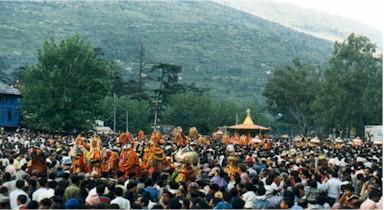
On the eve of the holy dip the precincts of Manimahesh lake seething with a large number of devotees, presents a colourful spectacle. On the Radhasthami day, pilgrims take the holy dip amid the chanting of mantras. Thereafter, pilgrims offer prayers to Mount Kailash and make floral offerings at the image of Lord Shiva established on one side of the lake.
The spectacular view of the Manimahesh lake and temple in Chamba district of Himachal Pradesh situated 13000 feet above sea-level.—PTI
By Balkrishan Prashar
Manimahesh — the holy Kailash — is located at an altitude of 5656 m. Down the foothills at an altitude of 4170 m nestles the scintillating Manimahesh lake. Mount Kailash, believed to be the abode of Lord Shiva, falls in the Bharmour tribal valley of Chamba district. This pilgrimage centre gains importance on two religious occasions, one on the Janamashtami and the other on Radhashtami. Only saints and sages grace the former while people from all walks of life undertake the latter.
Beginning on September 15, the Chhari Yatra in which the holy mace of Lord Shiva is carried to Manimahesh from the 1000-year-old Lakshmi Narayan temple in Chamba town marks the inauguration of this sacred occasion. The devotees reaches Manimahesh lake on September 22 to take the holy dip.
Apart from the religious fervour, the steep hills and pointed crags glowing with crimson light, rippling springs and splashing cascades arrest the sensual consciousness of the travellers.
The Manimahesh yatra becomes more delightful and enjoyable when the devotees sweep into the sprawling Bharmour tribal valley. Located at an altitude of 2195 m, the valley has a cluster of 84 hoary temples popularly known as ‘Bharmour Chourasi’.
These temples were built as a sequel to the visit of 84 sidhas from Kurukshetra to Manimahesh. While en route to Manimahesh, they were warmly welcomed by the King of the erstwhile Chamba state at its capital Brahmapur (now Bharmour).
The sidhas were pleased with the King’s courtesy and blessed him (as desired by the childless King) with an heir. The blessings worked and the King built these temples in their honour.
The idols in each shrine are dedicated to different deities. However, the Manimahesh temple among them is truly eye-catching.
The oval-shaped Manimahesh lake is 14 km from Hadsar. The distance of 13 km is marked with steep ascent, which has to be inevitably trekked. Here is the tough ordeal for the devotees. With two enchanting deep vales the Baandar Ghatti and Bhairon Ghatti, nature offers the pilgrims a plethora of experiences.
Gauri Kund and Shiv Karotary are two different places, where as the legend has it, the Lord Shiva’s consort, Parvati, and Lord Shiva bathed, respectively, on the Radhastami day. The pilgrims follow the tradition.
On the eve of the holy dip the precincts of Manimahesh lake seething with a large number of devotees, presents a colourful spectacle. On the Radhasthami day, pilgrims take the holy dip amid the chanting of mantras. Thereafter, pilgrims offer prayers to Mount Kailash and make floral offerings at the image of Lord Shiva established on one side of the lake.
posted by Avnish Katoch @ 10/25/2005 07:48:00 PM
0 comments
![]()
![]()